 The Spectator The independent student newspaper of Valdosta State University


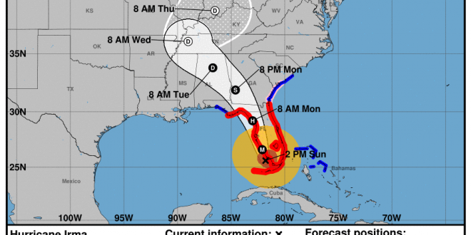
On Sept. 10, 2017 at 2 p.m. the National Weather Service released new predictions that show Hurricane Irma set to make landfall south of Naples, Florida on Sunday evening. This is after the storm passed over Key West, Florida this morning and made landfall as a category 4 hurricane. Deaths are already reported in Key West. It is expected that winds in the eye wall of the storm will exceed 120 mph.
A Hurricane Warning has gone into effect for Lowndes County, Georgia as of 5:36 p.m. on Sept. 9. Stay tuned for more emergency alerts.
The storm is on track to move into Southeast Georgia on Monday morning a few hours before noon. Orlando, Florida is expected to be covered by Hurricane Irma on Sunday evening near 8 p.m. The center of the hurricane is predicted to reach Valdosta around 2 p.m.
In the most recent predictions released by the National Weather Service, the winds in Valdosta are set be hurricane force meaning sustained winds between 75-100 mph. The current approximation shows sustained winds of 75-80 mph in Valdosta nearing 2 p.m. Gusts of wind could reach over 100 mph.
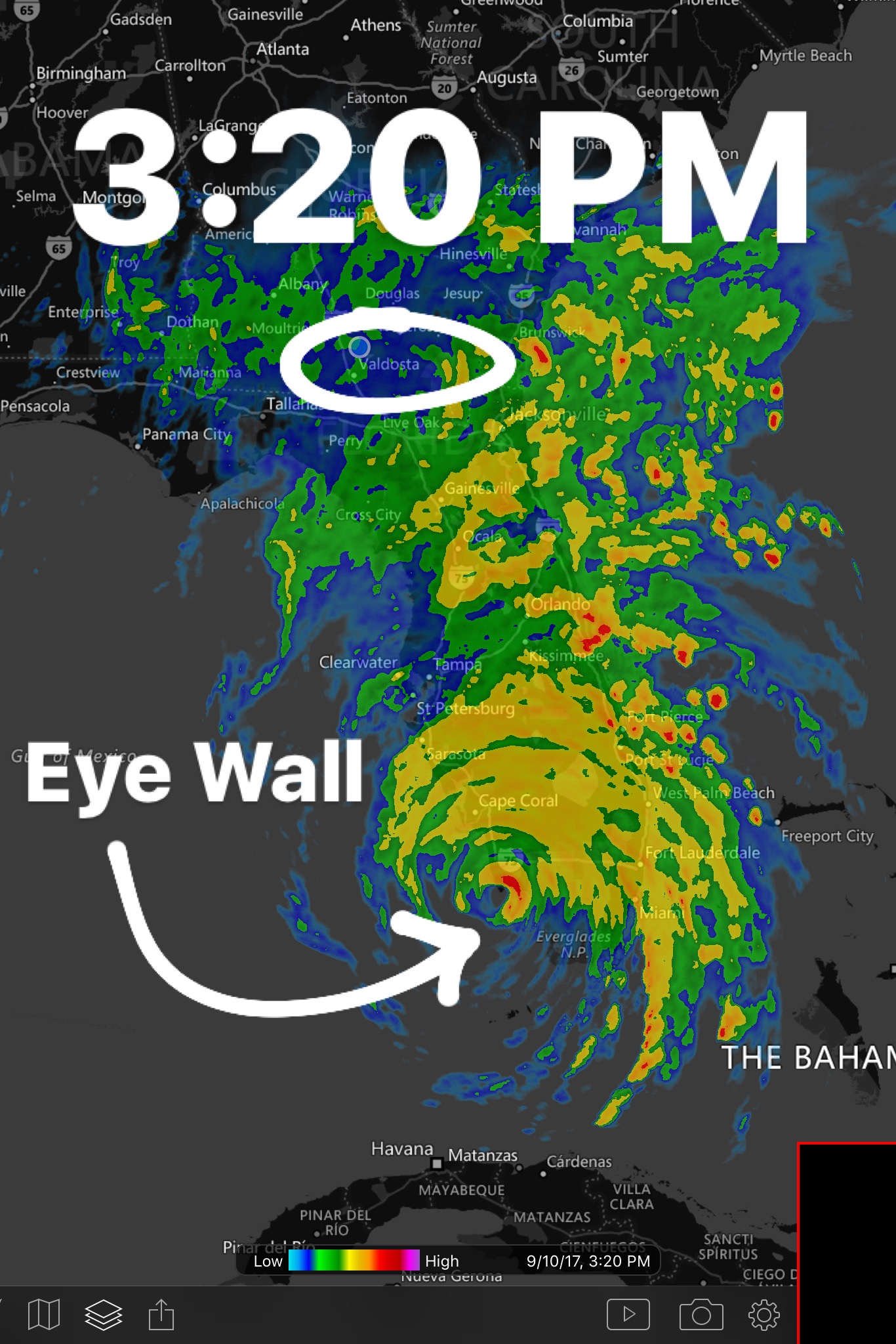
Hurricane Irma made landfall in Marco Island, Florida at 3:20 p.m. The eye wall is currently over the Naples, Florida area. Winds are 130 mph is Marco Island and Naples. Valdosta, Georgia is beginning to encounter Hurricane Irma’s outer bands so expect higher than normal winds (15-30mph) and steady light-moderate rain. As Sunday night nears prepare to stay in your home or shelter. Overnight Hurricane Irma will move closer and will gradually bring heavy, dangerous winds and rain with potential flash flooding. Expect the eye wall to be near Valdosta, Georgia around 2 pm on Monday.
Winds are expected to be a sustaining 45 mph at 4 a.m. on Monday morning. These will increase much higher as the hurricane wall moves closer to Valdosta, Georgia. Expect hurricane force wind throughout Monday. Expect sustained winds of 65 mph at 10 a.m. tomorrow, on Monday.
South Florida is experiencing extreme hurricane force winds and massive storm surges as well as inches of rains. Valdosta, Georgia has been placed under a hurricane warning which means that hurricane force winds are imminent in the Valdosta area. Flash floods and flooding is predicted for the Valdosta area.
Moody Air Force Base has announced that it will be closed due to Hurricane Irma as well as many other Lowndes County businesses. Many businesses are boarded up to prepare for the sustained hurricane force winds of 75 mph or more. Please stay off of the roads tomorrow evening and Monday and have a plan for when the hurricane strikes.
The eastern side of a hurricane tends to feature the most instances of tornadoes. Please be aware of this as you are looking at the forecasted tracks. Valdosta is located on the eastern side of the hurricane in the most recent prediction track. Valdosta residents should anticipate tornadoes and severe winds. Valdosta is expected to be affected by a category 1 Hurricane Irma. The eye wall of a category 1 hurricane is the equivalent to an F1 tornado. Please keep this in mind as you seek shelter in your home.
If you are a student remaining on campus during Hurricane Irma please stay informed on precautions and safety guidance before, during and after the storm. RA’s in each dorm hall will be providing information to keep those staying on campus safe. All students that live on VSU campus must complete the Hurricane Housing survey.
For those who are off campus and are in or around the projected path of the hurricane, prepare your supplies before Monday. The hurricane is expected to begin impacting the Lowndes County area Monday morning at 4 a.m. Tropical Storm force winds are expected in Valdosta and the surrounding areas during the first interaction with Hurricane Irma starting today.
Power outages are expected. Please plan accordingly.
Make sure that your household has a plan for when disaster strikes if you are not evacuating ahead of time. This includes, but is not limited to, placing any stray items that are currently outside into your home or garage, clear off any front or back porches such as chairs and tables, and, if possible, park your cars inside of a garage or under a stable covering. Winds are expected to be the most extreme part of our interactions with Hurricane Irma, so treat this storm as you would treat a tornado watch/warning.
The National Weather Service advises you stay in a room that is centralized in your home and that has no windows, on the lowest level of the house, if possible. This is the safest location to be in during times of severe winds. Fill bottles with water in the event that water treatment facilities become inoperable and keep shelf-stable foods near in the event that power is shut off and you are not able to cook or use your fridge. If power does shut off, try to keep your fridge door shut, as this will help to preserve the food that is inside and will keep the cold in for as long as possible. A battery operated emergency radio can be useful too if the power is not working.
Stay safe and try to keep your phones charged going into the storm just in case the power is out for an extended amount of time.
The Spectator will continue to relay all information that is provided by the National Weather Service and local authorities regarding Hurricane Irma.
Follow us on social media for more updates on Hurricane Irma.
Story by Seth Willard. Photos by the National Weather Service and MyRadar app.